Data Pre-processing
RUBEM model applications require data input at a specific format and quantity. This manual provides the steps for using the preprocessing scripts to prepare model data for the RUBEM model. The scripts described here are available in the RUBEM repository on GitHub. We recommend that you use a specific Conda environment for this step.
Conda Environment
A conda environment is used to run the scripts available for preprocessing. A conda_env.yml file is available for creating the environment with necessary libraries and packages for running all scripts. For more details see the related documentation.
Use the terminal or an Anaconda Prompt for the following steps:
Create the environment from the environment.yml file:
conda env create -f conda_env.yml
Activate the new environment:
conda activate myenv
Verify that the new environment was installed correctly:
conda env list
Available Scripts
TIFF/GeoTIFF to PCRaster Map File Format
The function of the script allows to convert a file in format .tif to a .map file.
Note
The model requires input rasters to be in PCRaster map format, each file also has to match the appropriate PCRaster value format, see File Formats for more information.
For correct output file format code, change the line 55 (outputType) from preprocessing/tif2map.py must be modified according to table follows:
Soutce type |
Target value scale |
|---|---|
GDT_Byte |
VS_BOOLEAN |
GDT_Int32 |
VS_NOMINAL |
GDT_Float32 |
VS_SCALAR |
GDT_Float64 |
VS_SCALAR |
Call the function as shown:
tif2map('/path/to/files/to/be/converted')
TIFF/GeoTIFF to PCRaster Tss File Format
The function of the script allows to convert a series of .tif to pcraster map-series at format *.001, *.002 …. These maps represent the meteorological forcing map-series, that are series of input maps with the time step indicated in each filename. The filenames have a strict format with 8 characters before a dot (.), and three characters after the dot.
Call the function as shown:
myModel= tif2pcrTss('/path/to/tiff/series','run','/path/to/clone.map')
First argument folder must have an structure as follows:
+---series
|   etp1.tif
|   etp2.tif
|   etp3.tif
...
Define second argument as “run” output files look like follow:
+---series
|   run00000.001
|   run00000.001
|   run00000.001
...
Third argument must be a file in format VS_BOOLEAN .map and nrOfTimeSteps must match the number of files to be converted (e.g. 8 files of etp, nrOfTimeSteps = 8).
Note
A pre-existing manifest.csv in the output directory is removed before
any map is written, so its presence after the run means every step
completed; a step skipped for being entirely no-data does not leave a
stale map at its target either.
PCRaster Tss File Format to TIFF/GeoTIFF
The function of the script allows to convert a series of pcraster map-series at format *.001, *.002 … to *.tif file format.
Call the function as shown:
pcrTss2Tif('/path/to/files/to/be/converted', '/path/to/DEM.tif')
First argument folder must have an structure as follows:
+---series
|   run00000.001
|   run00000.001
|   run00000.001
...
Second argument corresponds to the Digital Elevation Model in *.tif format used to get mask coordinates, projection and driver information for the conversion.
Note
When no georeference is given, every member must still share the geometry
of the first one; the GeoTIFF files then carry no projection. If the
requested no-data value cannot be represented by a member’s data type
(for example, the default -9999 on a Boolean or LDD map), the output
band is promoted to the smallest type that holds both the data and the
no-data value; a fractional no-data value is rejected on an integer
value scale. A member is also rejected if a valid cell already equals
the no-data value, which would otherwise make it unreadable as data on
the next read. As above, a pre-existing manifest.csv is removed
before any file is written.
Get Maximum and Minimum Value Map
This script allows you to get a map for variables as Minimum NDVI and Maximum NDVI from an historical series of files in *.tif format. To run the script, the following variables must be set:
Input_path =  'Directory containing the files'
dem_source = 'Path to Digital Elevation Model (DEM) with same resolution and size that input_path files'
outpath_min = 'Path and name minimum output file, example=/path/ndvi_min.tif'
outpath_max = 'Path and name maximum output file, example=/path/ndvi_max.tif'
Input_path folder must have an structure as follows:
+---series
|   etp1.tif
|   etp2.tif
|   etp3.tif
...
Note
outpath_min and outpath_max must not resolve to the same file, or
the maximum would silently overwrite the minimum. The computed minimum
and maximum are also rejected if a cell with at least one valid value in
the series already equals the requested no-data value.
Kriging Method
The RUBEM model uses meteorological forcing variables as precipitation and evapotranspiration. In general, meteorological data is available for specific locations (stations). This script allows you to generate spatialized maps for the variable from discrete data using the kriging method.
Call the function as shown:
Krige_Interpolation('/path/for/output/files/','/path/and/filename/dem.map','/path/and/filename/CSV/file/data.csv')
The first argument corresponds to the folder to store the maps generated. The second argument corresponds to the Digital Elevation Model in *.tif format used to get mask coordinates, projection and resolution for the files created.
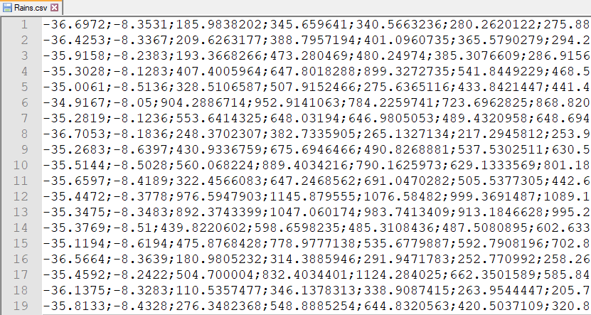
The third argument must be a file in format *.csv, each row corresponds to one station data. First and second columns correspond to station Longitude and Latitude, others columns contain data for each timestep. Figure below shows an example of the format of the file.
To use this script, the following conditions must be met:
A minimum of 3 stations data is mandatory, and every station must have its own coordinate: two stations sharing a coordinate are rejected even when 3 or more stations are present, because ordinary kriging cannot invert a system with two identical points;
No value data is not allowed; station coordinates and values must also be finite (no
nan/inf);Projection of station coordinates must correspond to DEM projection;
The DEM (clone) geometry must be north-up: rotated, sheared or south-up grids are rejected;
nrOfTimeStepsmust be minor or equal to the number of columns data;The variogram model must be one of
spherical,exponentialorgaussian, the only models both the variogram-fitting and the interpolation library support with the same three parameters (psill,range,nugget); for a geographic (longitude/latitude) coordinate reference system the variogram is fit with the same great-circle distance the interpolation uses;No interpolated cell may equal the requested no-data value (after the negative-value policy is applied), or it would be read back as missing.
Class A Pan Coefficient (Kp) Series
The model reads the Class A pan coefficient (\(kp\)) as an input raster
series (see Class A Pan Coefficient () raster series). When that series is
not available but the climate data behind it is, rubem preprocess kp builds
it from a wind speed series and a relative humidity series, with the formula of
the model itself:
where:
\(B\) – Class A pan border width, the fetch distance, between 20 and 30 m (m);
\(U_2\) – average wind speed at 2 m above the ground surface (m/s);
\(UR\) – relative humidity (%).
Call the command as shown:
rubem preprocess kp --wind /path/to/u2 --humidity /path/to/ur \
    --fetch 25 -o /path/to/kp --prefix kp
The two inputs are directories of GeoTIFF files (or explicit files, repeating
--wind and --humidity) that form two series of the same length on the
same grid. The members are paired in natural order of their file names
(u2_2 before u2_10): the nth wind speed raster is evaluated with the
nth relative humidity raster, and one member of the \(kp\) series is
written per pair.
The options are:
--wind: wind speed at 2 m (m/s), a directory of GeoTIFF files or a file (repeatable);--humidity: relative humidity (%), a directory of GeoTIFF files or a file (repeatable);--fetch: the fetch distance \(B\) in meters, one value for the whole grid; a value outside the 20 to 30 m the formula was fitted for is accepted with a warning;--fetch-raster: the fetch distance in meters as a raster on the geometry of the series, instead of--fetch; exactly one of the two is required;-o,--output-dir: where the members andmanifest.csvare written;--prefix: prefix of the member file names;--format:map(default) writes PCRaster maps named like the other input series (kp000000.001,kp000000.002, …),tifwrites GeoTIFF files named like the model outputs (kp00000001.tif,kp00000002.tif, …);--first-step: step number of the first member (default1);--nodata: missing value written to the members (default-9999.0).
A cell missing in the wind speed, in the relative humidity or in the fetch
raster is missing in \(kp\), and the command warns about it: the model
reports a \(kp\) member that carries missing cells, so the inputs should
cover every cell of the clone. Every member is written through a temporary
file and renamed into place, and manifest.csv is written last, with one row
per input raster (both sources of a member point at the same target), so its
presence means the run completed.
Note
The model refuses a \(kp\) raster that is not positive in every valid cell, as \(kp\) divides the potential evapotranspiration. The tool applies the same rule: it evaluates the whole series first and, if any cell of any member is not positive or not finite, reports every offending member with its number of cells and writes nothing. Such a result usually means the inputs are not in the units the formula expects (wind speed at 2 m in m/s, relative humidity in %, fetch distance in m).
The value range configured for the \(kp\) input, [0, 1], is only
reported by the model, not enforced, and the formula rises above 1 for a
relative humidity close to 100 %: a member with cells above the maximum of
that range is written, with a warning naming the member and the number of
cells.
To use this command, the following conditions must be met:
Both series must have the same number of members, and every raster must share the geometry (size, transform and coordinate reference system) of the first wind speed raster, as must the fetch raster;
The fetch distance must be positive, as a scalar and in every valid cell of the fetch raster: the formula takes its logarithm;
No valid cell may equal the requested no-data value, or it would be read back as missing;
mapmembers are written on a north-up grid with square cells, the only geometry the PCRaster map format expresses.